Robert Bell's
Wines of Canada
Since 1992
sub-Geographic Indication In British Columbia
The Regulations
(a) a geographical indication or subdivision must represent an area that is geographically distinct and has clearly defined boundaries;
(b) grape production in a proposed geographical area or subdivision must have reached commercially viable levels;
(c) at least two thirds of practice standards certificate holders in a proposed geographical area or subdivision, who produce at least two thirds of the total production of wine made from grapes grown in that area or subdivision, must have voted, by ballot, in favour of the proposed geographical area or subdivision;
(c.1) at least two thirds of registrants in a proposed geographical area or subdivision, who produce at least two thirds of the total grape production in that area or subdivision, must have voted, by ballot, in favour of the proposed geographical area or subdivision;
(d) appropriate consultations must have taken place within the region of the proposed geographical area or subdivision and there must not have been any credible objections that claim that the proposed geographical area or subdivision is not distinctive;Currently ( May 15th 2018) the only subdivision is the Golden Mile located in the Southern Okanagan region. The Okanagan Falls Winery Association submitted their application on Dec 3 2017.
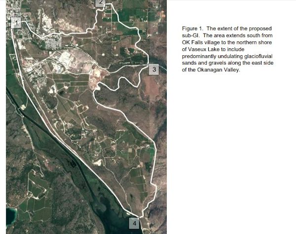
Dr. Scott Smith of Eterrna Consulting (in consultation with Dr. Pat Bowen of the Summerland Research and Development Centre, Agriculture and Agri-Foods Canada) evaluated the area outlined by the Appellation Task Group’s conceptual map of contiguous Sub-GI’s around the Hawthorne Mountain, West Skaha Lake, East Skaha Lake and Okanagan Falls areas. After detailed evaluation of this large heterogeneous area, Dr. Smith narrowed his focus to the unique Okanagan Falls area. Dr. Smith stated: “[F]ollowing detailed examination of geological, climatic, topographic and soil factors this rather large, heterogeneous area was narrowed down to focus on the unique surficial geology and resultant viticultural properties of the landscape on the east side of the valley from Vaseux Lake to just north of Shuttleworth Creek. Dr. Smith concluded that: “The proposed OK Falls sub-Geographic Indication (sub-GI) has a unique terroir combining climatic, topographic and soil characteristics that influence the development and performance of grapevines including the compositional development of fruit that determines wine quality. The essence of this sub-GI is a landscape created during deglaciation some 12,000 year (sic) ago. Most of the area is covered by what geologists call glaciofluvial deposits, sands and gravels that were deposited by glacial meltwater during deglaciation. The proposed sub-GI covers an area just under 800 ha. According to a provincial agricultural land use survey conducted in 2015 there are approximately 150 ha of vineyards within this area.”
The Naramata Bench has also submitted an application in April 2018.
The ‘Naramata Bench’ brand is firmly established in a regional socioeconomic context and particularly within the BC wine and wine tourism industry. The proposed sub-Geographic Indication (sub-GI) covers an area of just under 3,650 ha along the east side of the Okanagan Valley from Okanagan Mountain Provincial Park in the north to Penticton Creek within the City of Penticton in the south. The area includes approximately 250 ha of vineyards and some 50 wineries.
July 2020 the Cowichan Valley became British Columbia's new sub-GI.
There are nine official geographical indications in the province and five sub-geographical indications. The Cowichan Valley is the first sub-GI outside of the Okanagan and joins the Golden Mile Bench, Naramata Bench, Okanagan Falls and Skaha Bench in the Okanagan Valley.
Golden Mile
Naramata Bench
Okanagan Falls
Skaha Bench
Cowichan ValleyAdded 2022
- East Kelowna Slopes, comprising just over 200ha of vineyards overlooking Mission Creek in the central area of the Okanagan Valley, which is known for its premium sparkling wines.
- Lake Country, on the west-facing slopes above the Lake known for Pinot Noir and white varieties such as Pinot Noir, Chardonnay, Pinot Gris, Riesling, and Gewurztraminer.
- South Kelowna Slopes, comprising 130ha of vineyards on the slopes on the eastern shore of Okanagan Lake.
- Summerland Bench, on the western shores of the lake, where Pinot Gris and Gewurztraminer predominate.
- Summerland Lakefront, a small 7.5m stretch of land hugging the western shore of Lake Okanagan.
- Summerland Valleys, which includes some of the highest-elevation vineyards in the Okanagan Valley, around 35ha of predominately Chardonnay.
The designation is an official and protected term under British Columbian law, which can be included on the bottle.
Kelowna, British Columbia: On Tuesday June 28,2022 the Ministry of Agriculture and Food announced the approval of six new sub-Geographical Indications (sub-GIs) located in the Okanagan Valley, British Columbia. Summerland Valleys, Summerland Lakefront, Summerland Bench, East Kelowna Slopes, South Kelowna Slopes, and Lake Country are now protected terms under BC law representing a geographical area of origin for 100% BC VQA wine.
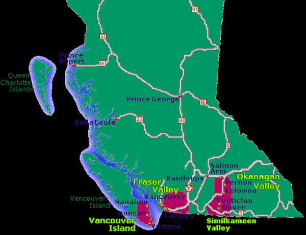
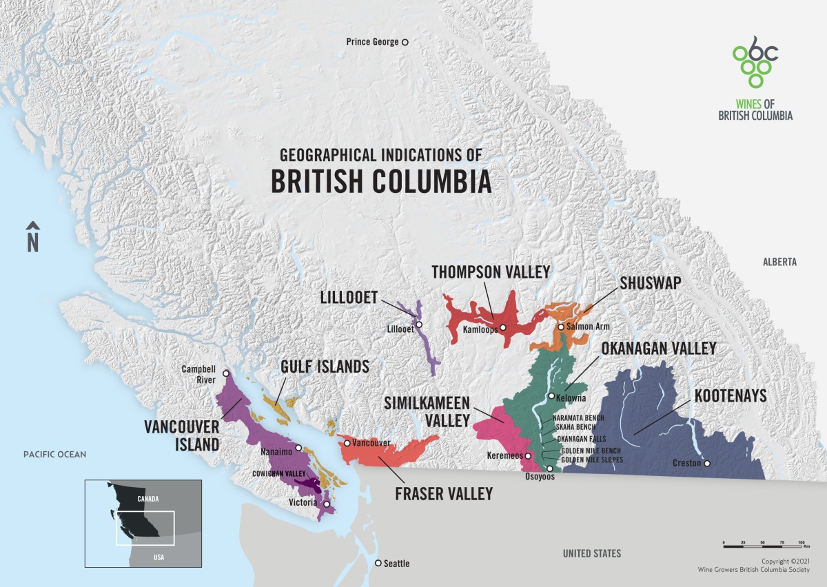
The Okanagan Valley is BC’s largest winegrowing region (175 km north to south), comprising 86% of BC’s vineyards (9,617 planted acres) and offers a range of diverse soil types, climatic conditions and resulting styles of wine.
Once approved, these sub-GIs can then be noted on wine labels to indicate a minimum of 95% of the grapes were grown from the specified region. British Columbia now features 21 Geographical Indications (10 GIs; 12 sub-GIs):
- British Columbia
- Vancouver Island (1 sub-GI)
- Cowichan Valley
- Gulf Islands
- Fraser Valley
- Lillooet
- Thompson Valley
- Shuswap
- Okanagan Valley (11 sub-GIs)
- Lake Country
- East Kelowna Slopes
- South Kelowna Slopes
- Summerland Valleys
- Summerland Lakefront
- Summerland Bench
- Naramata Bench
- Skaha Bench
- Okanagan Falls
- Golden Mile Slopes
- Golden Mile Bench
- Similkameen Valley
- Kootenays
Cowichan Valley is the only sub-GI of Vancouver Island.
Ontario has a number of Sub-Appellations Please see Ontario
What is a geographical indication?
A geographical indication (GI) is a sign used on products that have a specific geographical origin and possess qualities or a reputation that are due to that origin. In order to function as a GI, a sign must identify a product as originating in a given place. In addition, the qualities, characteristics or reputation of the product should be essentially due to the place of origin. Since the qualities depend on the geographical place of production, there is a clear link between the product and its original place of production.

Home | About |Sitemap | History |New | Contact Us |Tourism |©2022 Robert A Bell